
Degrees/Minutes/Seconds (DMS) vs Decimal Degrees (DD)

Degrees/Minutes/Seconds (DMS) vs Decimal Degrees (DD)
For positioning, we can find any location on Earth using latitude and longitude coordinates.
And we measure those coordinates using decimal degrees or degrees/minutes/seconds.
While latitude lines range between -90 and +90 degrees, longitude coordinates are between -180 and +180 degrees.
Do you notice how we use degrees for latitude and longitude coordinates? Let’s start with some key examples how come we use angular units.
A Review on Geographic Coordinate Systems
In a geographic coordinate system (GCS), we can reference any point on Earth by its longitude and latitude coordinates. Because a GCS uses a sphere to define locations on the Earth, we use angles measured in degrees from the earth’s center to any point on the surface.
The coordinates (0°N, 0°E) is where the equator and prime meridian cross. The funny thing is that if you look at this location on a map, it’s all ocean. But because GIS professionals sometimes mistakenly define their project when adding XY coordinates, (0°N, 0°E) had turned into a fictional location called “null island”.
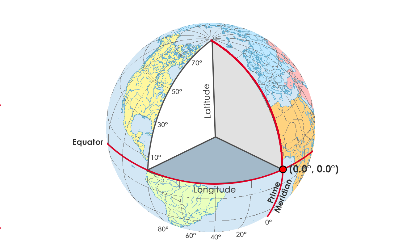
When we move northward along the prime meridian, the longitude value stays fixed at 0°. But the latitude angle and coordinate increases because we move northward.
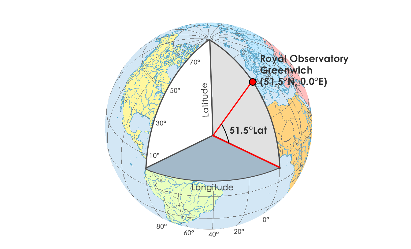
If we move northwards at an angle of 51.5°, this positions you on the Royal Observatory in Greenwich, England as pictured below. Actually, this is why the 0° line of longitude is the reference starting point. From the Greenwich Meridian, we can find positions east and west.
Because the prime meridian is the 0° starting point for longitude coordinates, everything is referenced from here.
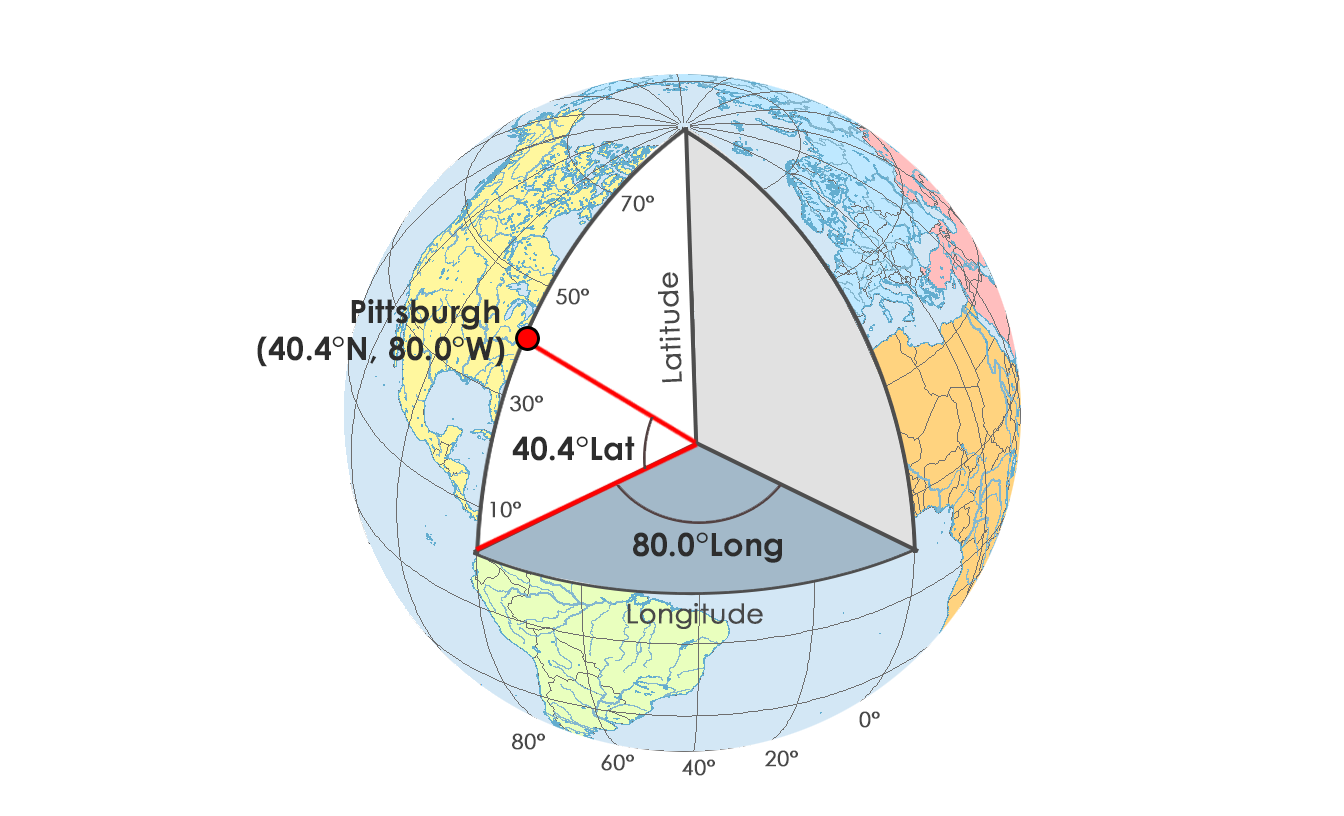
For example, we can change the angle 80.4° west. This moves us 80.4°W away from the prime meridian. And just by chance, Pittsburgh is located on this line of longitude at about (40.4°N, 80.4°W)
To recap:
The equator is 0° latitude where we measure north and south. This means that everything north of the equator has positive latitude values. Whereas, everything south of the equator has negative latitude values.
Alternatively, the Greenwich Meridian (or prime meridian) is a zero line of longitude from which we measure east and west.
Decimal Degrees vs Degrees/Minutes/Seconds
One way to write spherical coordinates (latitudes and longitudes) is using degrees-minutes-seconds (DMS). Minutes and seconds range from 0 to 60. For example, the geographic coordinate expressed in degrees-minutes-seconds for New York City is:
LATITUDE: 40 degrees, 42 minutes, 51 seconds N
LONGITUDE: 74 degrees, 0 minutes, 21 seconds W
LONGITUDE: 74 degrees, 0 minutes, 21 seconds W
But you can also express geographic coordinates in decimal degrees. It’s just another way to represent that same location in a different format. For example, here is New York City in decimal degrees:
LATITUDE: 40.714
LONGITUDE: -74.006
LONGITUDE: -74.006
Although you can easily convert coordinates by hand, the FCC has a DMS-Decimal converter tool that can convert between decimal degrees and degrees/minutes/seconds.
Try For Yourself
When you put two coordinates together as a pair (X, Y), you can locate anything on Earth with a geographic coordinate system.
Anything!
You can express coordinates in primarily two different ways. For example, you can use decimal degrees or degrees-minutes-seconds. But there are even new growing ways to of addressing the world such as What3Words.
After your locations are in a GCS, geographers often project their locations in a Projected Coordinate System (PCS). PCS like the State Plane Coordinate System (SPCS) or Universal Transverse Mercator (UTM) are always based on a GCS that is based on a sphere.
No comments:
Post a Comment