Friday, August 21, 2020

Use This Easy Trick to Cure Procrastination

Use This Easy Trick to Cure Procrastination

Procrastination is something that we all struggle with at some point in our lives. For as long as humans have walked this earth, we have been struggling with delaying the things that really matter to us.

We set huge goals, feel an incredible surge of motivation, and then when the time comes to take action on those goals, we just can’t force ourselves to do it.

Why does this happen? Let’s talk about it.


Why Do We Procrastinate?

Before we talk about how to combat procrastination, it’s important to understand why procrastination is such a common issue for people.

It’s time to bring a little behavioral psychology into the mix.

Through research, psychologists have discovered a phenomenon called “time inconsistency.” Time inconsistency refers to the tendency for our brain to value immediate rewards as opposed to delayed rewards.

An easier way to understand this concept is by imagining you have two different people living inside of you: your Present Self and your Future Self.

When you make a to do list, or you set goals, you are making plans for your future self and envisioning what you want your life to look like in the future. (Ex: By Sunday night I will have completed that essay)

However, while the Future Self can set goals and make plans, the only person that can actually take action on those goals is the Present Self. When the time comes to make a decision, you are no longer thinking about the future, you are in the moment, which means your present self is the one running the show.

The Present Self really likes instant gratification and doesn’t value long term pay off. The only goal that the present self has is to feel good right now, which means that the present self and future self are constantly at odds with one another.

This is why it’s completely normal to have conflicting emotions when you are about to make an important decision.

Your future self knows you should go to the gym, but your present self wants you to sit down on the couch and watch TV.

Your future self knows you should stay in and work on the paper you have due Monday, but your present self wants you to go get drunk with your friends.

Your future self knows you should go approach that attractive girl at the bar, but your present self wants you to stay at the booth with your friends and avoid the possibility of rejection.

Most of the time, our present self wins this internal debate inside our head because it requires your brain to expend the least amount of energy, and this cycle of self-sabotage can lead us to some pretty dark places.


How Do You Start Taking Action?

The easiest way to combat your brain’s constant need for instant gratification and spring yourself into action is to use something called “The 5 Minute Rule.”

The rule is pretty self-explanatory, all you are going to is sit down and commit to working on the task that you are avoiding for only 5 minutes. No more, no less.

Doing this accomplishes two things.

First off, you’re giving yourself an out. Most procrastination is built on avoidance of a potentially stress-inducing activity. It’s not that we don’t want to start working on the project, we actually really do want to start it! We just don’t want to work on it for hours and make ourselves miserable.

By only committing to the task for five minutes, you are giving yourself the option of giving up after five minutes if the act of starting the task is as horrible as you thought it was going to be.

Second, you are actively exposing yourself to the activity, which always leads to it being less painful than you thought it was going to be.

The best part is, and you’ve probably experienced this more than a few times, once you start the activity you actually feel pretty good!

Once you’ve redirected your focus to completing the activity as opposed to avoiding it, your stress levels begin to decrease naturally as you focus your energy in a different way.

This graph below provides a clearer picture of how this phenomenon works.

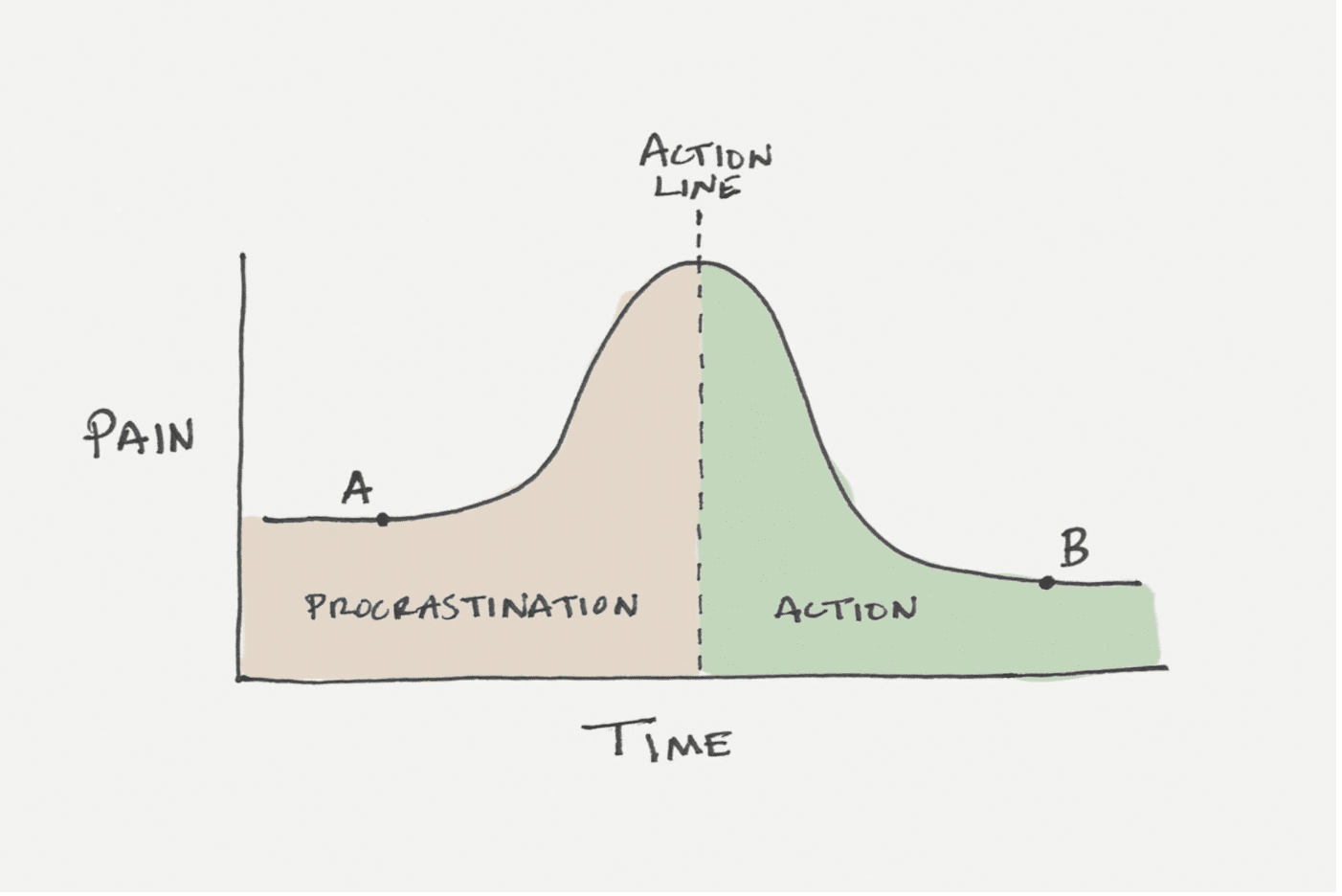
As you can see, the level of pain you feel while you are procrastinating is significantly less than the pain you feel when you are in the middle of the activity.

The problem is not doing the work, the problem is starting the work.


Where to Go From Here

I hope that this brief article on overcoming procrastination has given you some actionable advice to start implementing into your day to day life.

At the end of the day, starting is most often the hardest part of completing any task.

When you can remove the initial friction you feel to complete a task by working on it for just five minutes, you’ll be amazed at how much more you get done on a day to day basis.


Related Articles You Might Find Interesting

Monday, August 3, 2020

Benefits of GIS in Urban Planning

Benefits of GIS in Urban Planning 

Investigating the Squatter Settlements in Eskisehir, Turkey


Traditional methods of information management are hard to use in the planning process of problematic urban areas such as squatter settlements. GIS provides the capability for dynamic query and analysis, display of information and a more understandable representation. By introducing GIS, the authors analyse the social and infrastructure possibilities of the squatter settlements in Eskisehir Municipality. They determine areas with inadequate public services and infrastructure, and provide basic solutions.

The problems of large metropolitan cities have been comprehensively studied by many researchers. Nevertheless, a country that just consists of a few very large urbanised areas arbitrarily embedded in a rural context is not viable and not optimally sustainable. A network of medium-sized cities that are evenly distributed over the territory is more feasible. Therefore it is important to also investigate the problems of these smaller cities. The city of Eskisehir, Turkey, has been chosen as a case study. This city is located in the northwest of Anatolia at an equal distance from the primary metropolis Istanbul and the capital Ankara.

center of Eskisehir, Turkey

The city Eskisehir in Turkey

Demography: increase people living in urban areas

Turkey’s urban population has grown from 23.6 million in 1985 to 44.1 million in 2000. During this 15-year period, the proportion of people living in urban areas has increased from 45.2% to 65.1%. These figures show that although Turkey’s level of urbanisation is lower than in western countries the rate of growth is very high. One of the worrying results is the uncontrolled settlement of low-income families in squatter areas. Housing is a basic human right, but without effective control it may harm the ecological balance. The construction of informal houses was not common in Eskisehir until the 1970s. As a result of rapid industrialisation, housing stock became insufficient after the 1970s and squatter settlements started to concentrate around industrial sites and along the main roads. Today, about 30% of the population lives in squatter areas. In 1997, over 154,000 people lived in the 16 squatter areas, whilst in 2000 the number had risen to nearly 169,000. Settlement is made easy by property developers who divide the land into parcels, often illegally. The developers do not put much effort into constructing basic services because their main interest is profit; they are not concerned with living standards or environmental balance.

Planning and GIS

Planning involves determining appropriate future decisions and actions through a series of choices. Making choices requires, in addition to thorough planning knowledge, comprehensive (geo-)data about the past, present and future. The information may be descriptive, predictive or prescriptive in nature. Appropriate and efficient management of information greatly improves the quality of planning. Generation of the proper type of information is very difficult with manual methods. GIS provides many basic functions for appropriate and efficient management of geo-information. Essentially, GIS supports the collection, maintenance, analysis and display of spatially related information. GIS data enable multiple viewpoints to be considered and provide the capability for dynamic query and display of information, and a more understandable representation. On the other hand, the accessibility of digital data may cause abuse and misuse, raising fundamental issues of data security, responsibility and reliability.

Understanding the planning area

Statistics, reports, articles, aerial and close-range photos, satellite images, maps and drawings all aid in understanding the planning area and its problems. Alternative solutions may be developed by importing this data into computer models. These models may predict, for example, demographic changes and land use modifications or simulate traffic flow. Often these computer models are implemented as stand-alone software. GIS facilitates by providing digital geo-data and display of intermediate and final results. Arriving at the most appropriate solution requires communication and collaboration among many stakeholders. Communication is best done through visualisations such as images and maps rather than through bare text. GIS is a perfect visualisation aid. So, GIS makes model creation and interpretation easier and provides understanding that may otherwise not be achieved.

Database

A database was created by an extensive survey of land use and population statistics of Eskisehir. All analogue maps and plans were scanned, and blocks and buildings digitised. Numerical data were converted into tables, graphs and maps. A basic image and GIS layers were created as thematic maps in a topological data structure. Topologically coded geo-data enables spatial query and analysis whilst large and complex sets of diverse data types can be efficiently managed. Issues such as insufficiency of public services and infrastructure and accessibility of public services can in this way be addressed more easily than by traditional methods. All the themes such as districts, public facilities, blocks and houses were stored as separate layers, which can be easily represented graphically. Many layers were created using the basic image as source. Data created with the Turkish GIS software package NetCAD were converted to data compatible with ArcGIS 8.3.

Analysis

The analysis and overview are based on relevant literature, amnesty laws, statistics from the State Statistics Institute created in 2000, maps, master plans and reconstruction improvement plans (upgrading), field surveys, data from concerned authorities and from the reports written by these authorities and organisations. The parameters used during analysis included:

  • population
  • number of storeys
  • sufficiency of public services according to the planning standards
  • walking distances to public services
  • area of public services.


From the descriptive information such as infrastructure, population data and area of the districts, the following parameters were derived:

  • floor area coefficient of the houses
  • presence of basic services and infrastructure in uncontrolled settlements.


Results

As a result of legislation of squatters by amnesty laws and weakened fear of demolition of houses, the number of the squatters has increased year after year. After the last amnesty laws, municipalities were allowed to upgrade district plans and increase the number of storeys to four. Compared to standards and law, public services are inadequate; the ratio of services to the number of people is low and walking distances are too high. Even the ratio of proposed public services to the existing population is too low according to the standards defined in developmental regulations. While 98% of the houses in 1989 had a septic tank, in 2002 60% of the houses were connected to the sewer system, 39% had a septic tank and 1% did not have any disposal system. Nearly all buildings have electricity and indoor running water (99.2% and 91.5%, respectively). These proportions are larger than Turkey’s average. None of the districts are connected to a source of natural gas. Suitability factors, factor scores, factor weights and permitted land use conversions can be specified for all land use by using GIS. Automated mapping allows the efficient handling and dissemination of thematic information enabling quick map making for planning and decision making.

Conclusions

Housing demands in Eskisehir will increase in the foreseeable future. To prevent future settlement of squatters, the following has to be done:

  • Eskiºehir Municipality should take preventive measures by identifying possible development areas for settlement in agreement with development of industrial sites, housing areas proposed in the master plan, municipal services, public land and the transportation network
  • after identification of settlement areas, site and service specifications should be ensured by constructing roads, water and electricity supply, drains and sewerage, layout of plots and service areas
  • the use of GIS techniques should be stimulated to support settlement development by using planning models and scenarios and proper data in digital format.


Google Maps: Eskisehir


Read more about GIS
Read more about Urban Planning