Monday, November 2, 2020

History and Life... Wike: Stop Watering Your 2023 Ambition With the Blood of Igbo Youths 😭😭

Wike: Stop Watering Your 2023 Ambition With the Blood of Igbo Youths 😭😭
By Chidiebere Nwobodo 

I am not a fan of Nnamdi Kanu neither am I an IPOB member but as Igbo man who will never deny his tribal identity, even at gun point, I have to strike a balance between IPOB's extremism and Wike's undeclared war against southeast extraction of Ndigbo. In the heat of #EndPoliceBrutality protests, Nnamdi Kanu—in the quest cum overdrive to own a struggle he did not initiate, committed strategic blunder with his inciting and thoughtless utterances that nearly pitched other Nigerians against Ndigbo. 

But thank God for Igbo elders who saved the day by putting the narrative in its proper perspective. Nnamdi Kanu doesn't understand that there is a time when silence is golden; you don't talk for talking sake, especially at a time of national crisis. Kanu said he was misconstrued and had apologized for that senseless comments that were inflammatory enough to provoke genocide against Ndigbo. 

#EndSars movement had nothing to do with tribal chauvinism or secessionist agenda of any kind. It was a mass revolt of frustrated Nigerian youths against kleptomaniac political elites; that cut across Nigeria. The whirlwind of the protests were palpable, especially in the south and middle belt states. The jolted and panicked political establishment, in an attempt to use their greatest weapons of enslavement, which are ethno-religious proclivities, found Nnamdi Kanu's irrational outburst at that moment a willing tool for their divide-and-rule propaganda. Thanks to Nigerian youths for not falling for that parochial and outdated antics. 

After the unprovoked massacre of unarmed youths at Lekki Tollgate by daredevil soldiers, violence erupted across the country. Many lives and properties were destroyed by rampaging youths tagged hoodlums. Not even Southeastern states of Abia, Enugu, Ebonyi, etcetera, were spared.  It was a season of national anarchy and chaos. But Rivers State incidents took a different turn of ethnic cleansing, because Wike was waiting for this opportunity to deal with Southeastern Igbos; just to impress the Caliphate north and position himself for 2023. He is still angry with southeast politicians for voting for Atiku Abubakar in the PDP presidential primary instead of his preferred choice. 

Governor Wike found IPOB's excesses as a facade to masquerade his devious and vile agenda and unleashed sadistic attacks on southeast people living in Rivers State. As much as I am not an advocate of violence and barbarism, Rivers State was not the only state where soldiers, police officers and civilians were murdered during the crisis. Wike, blinded by ambition, teetering on the path of self-destruction, has sanctioned bloodletting against Igbo youths in the state. People are being dragged out of their homes, shot at, just because their were perceived as Igbo youths from the East. 

And I ask: who do we blame for destructions in Lagos, Abuja, Taraba, Adamawa, Plateau, Cross River, Enugu, Ebonyi, Abia, etcetera? IPOB I guess? very laughable. I saw pictures of Rivers State youths that led protests in the state. These were not IPOB members, but aggrieved youths clamoring for a new Nigeria. How come Wike is scapegoating IPOB alone for the destructions in the state, if not for political reasons to rubbish and victimize Igbo youths of southeast extraction? 

When Wike addressed protesters on the first day of protest, after his ill-conceived ban collapsed, he alluded to some politicians from southwest sponsoring the protests. And stated that he would not play second fiddled. His anger was that when Akin Fakorede—then Rivers State SARS commander, was his nightmare that no one came to his rescue. All of a sudden, it has become IPOB. And I ask: can phantom politicians from southwest bankroll IPOB activities in Rivers State? that's how fallacious Wike's flawed narrative is. 

These were the same youths who risked their lives to defend Governor Wike's mandate when the so-called Federal Might was unleashed on him in 2015 and 2019 elections. Wike never bothered whether they were IPOB members or Igbo youths from the east. In fact, I can remember the same Nnamdi Kanu giving instructions to Igbo youths to defend Wike's election against riggers. Wike never refused that offer of support. IPOB was not a terrorist organization then, until Wike started nursing ambition for 2023. 

Mind you, Fulani herdsmen have killed a lot of people in Rivers State since Wike mantled the saddle as governor; he never raised an eye brow—nor proscribed them as terrorist organization, because he is in bed with Gov. Aminu Tambuwal and seat of Sokoto Caliphate. The Caliphate north is preparing to use Wike and Rivers State resources in 2023 like they used Rotimi Ameachi in 2015 to dethrone his fellow South-South brother from Aso Rock Villa. They have started dangling the same carrot of vice presidency to him like they did scammed Ameachi. Hegemonic caliphate north has seen another instrument of divide-and-rule in Gov. Wike. The Ikwere son has foolishly yielded. 

Gov. Wike has found IPOB as a pawn in the political chess game. Unfortunately, our neighbor under the cloak of governor, has been supervising albeit sadly, the gruesome killing of our people in Obigbo, just to send a message to his slave masters up north that he should be trusted with power than Igbos of southeast in 2023. He thinks he is in competition with the east as regards presidential aspirations. Wike needed N79 billion naira refund from Abuja to kick-start his campaign. So he must show how much he detests his neighbors just to win the hearts of the cabal, to enable them release this "blood money" to him. 

Gov. Wike like a buffoon and megalomaniac in power, doesn't learn from history. Ken Saro-Wiwa ordeal can serve as great history book for him. You don't kill your brothers to please a stranger whose sole agenda is to perpetually enslave you—he is only dividing you to weaken you more. Like a bull in the China shop, Wike is set to wreck a lot of havoc on the psyche cum sensibilities of his eastern brothers, just to prove how far he can go as a stooge of the north. Unfortunately, he is swimming in the pool of reveries and hallucinations. Wike is a fly that thinks himself a bird. 

 IPOB is not as deadly and bloodletting like bandits, Fulani herdsmen and Bokoharam, yet those slave masters urging Gov. Wike on, have not openly criticized the heinous activities of these groups, even in their own domain. Wike, remember these words: power is transient and blood of Igbo youths being spilled in Obigbo will forever hurt you. We WILL NEVER FORGET! #ObigboBleeds

HISTORY YOU NEED TO KNOW *OBIGBO NOT OYIGBO, THE TRUTH NOT FALLACY*

 ‎

*OBIGBO NOT OYIGBO, THE TRUTH NOT FALLACY*.
"Don't mind those stupid Igbophobic bunch of idiots.They think they can bury the truth and murder history forever. It was Obigbo not Oyigbo even before the artificial and erroneous creation of Nigeria.

Obigbo was part of East central State when Gowon created Rivers state out of Eastern Nigeria. It was in 1979 when Melford Okilo was the governor of Rivers State and Mbakwe governor of Imo State. Okilo wrote the then civilian president of Nigeria Shehu Shaggari on the need to cede Obigbo to River State judging from it's geographical proximity to Port-harcourt the capital city of River State.

He went further to argue that Yakubu Gowon erred in the boundary demarcation between the Old Imo State and Old River State by not using natural landmarks like rivers, lakes and mountainous forms rather he used ethnic identity and affiliation.

By this, he appealed through the boundary adjustment commission that the boundary be adjusted to accommodate Obigbo as part of River State siting the imo river has provided a natural boundary.The Boundary Adjustment commission saw the logic in his argument and convinced the presidency of Shehu Shaggari on the need.

<script async src="https://pagead2.googlesyndication.com/pagead/js/adsbygoogle.js"></script>
<ins class="adsbygoogle"
     style="display:block; text-align:center;"
     data-ad-layout="in-article"
     data-ad-format="fluid"
     data-ad-client="ca-pub-4217567624535883"
     data-ad-slot="4647042048"></ins>
<script>
     (adsbygoogle = window.adsbygoogle || []).push({});
</script>
As at then, large Deposits of hydro-carbon had been discovered at Afam and other communities in Obigbo arousing greed from people who thought Igbos would not have oil in their land. Mbakwe, the then Governor of Imo State objected to this move, countering the argument that Rivers State was created by Gowon to give voice to Eastern minorities that have been crying of Marginalization from their Igbo brothers in the old Eastern region dominated by the Igbos, therefore the objective of the creation of Rivers State was to have a State devoid of Igbo influence.

Mbakwe argued that it would be politically incorrect and catastrophic to have an Igbo speaking clan in a State with a state stereotyped hatred for the Igbos. River State then was under the control of NPN the same party in control of the government at the center led by Shaggari while Imo was in opposition NPP led by Zik.

The matter ended up in supreme court with NPN influencing the judgement, the court ruled that Obigbo be ceded to Rivers but River State. Mbakwe accepted on the condition that another boundary community in any part adjoining the two State should equally be ceded to Imo to make up for the lost, the Court and River State government accepted and Ohaji-Egbema, another Igbo speaking community gowon drafted to Rivers State during his obnoxious state creation, was returned to Imo State in exchange. though not all of Egbema community returned. Out of the 12 communities in Egbema, 10 were returned to Imo while River State retained the other remaining 2. That is why you have the same Egbema people in both Imo and River State and Asa-Ndoki in both River and present day Abia State.

After Okilo got what he wanted, in creating a local government for the people of Obigbo, instead of naming the Local government to reflect the aboriginal and ancestral nomenclature the people over time were known with, for best known to them, apparently to play this fast game they (Ijaws) played on the Ikwerres that resulted to them changing their igbotic communal name to things that sound strange to igbo system of name.

When (N)wike was talking rubbish of Igbos being migrants in River State, I was like; this man lack sense of history or simply being intelligent by half. Obigbo people are not like the Ikwerre's played politics with their ethnicity and who are suffering from crises of identity today. You can't be bearing Igbo name and say you are not igbo and speaking igbo dialect. Ethnicity is not defined by politics, though it can be influenced by it.

So Nwike and all the minion Igbophobias, take note; we know where Igbo land extends to and it is not definitely limited to the five South-East States."

“Copied “

Sunday, November 1, 2020

How to Make Maps with ArcGIS Pro & Adobe Illustrator in 3 Steps (hint: AIX)


ArcGIS Maps for Adobe Creative Cloud

How to Make Maps with ArcGIS Pro & Adobe Illustrator in 3 Steps (hint: AIX)

ArcGIS Maps for Adobe Creative Cloud 2.2 is here! This post will show you how to take advantage of ArcGIS Pro’s new AIX file format for an efficient and user-friendly Adobe Illustrator map-designing experience. In addition to the AIX advantages, at the end of this post you will also learn how to use the new geospatially enabled AIX – available today with the new 2.2 release. Read “A Brief History…” below for more information on this new feature.

There are three Maps for Adobe account levels: complimentary (free), Plus, and the ArcGIS account holder. One of the many great things about this Pro-to-AIX workflow is that – if you are an ArcGIS Creator or GIS Professional user, you already have access to these featuresFor all of you mappers who want to explore this new feature, download the Maps for Adobe plug-in here.

A Brief History of Maps for Adobe

2015. In 2015, a few of us at Esri were conceptualizing a mapping plug-in for Illustrator. At this point in Maps for Adobe history, we had a nifty prototype that could pull data from ArcGIS Online into an Illustrator file.

May 2017. Version 1.0 is released! Since this release, Maps for Adobe users can build entire maps with Maps for Adobe inside Adobe Illustrator. Maps for Adobe continued to grow with subsequent updates, all the way to version 1.5.2, released March 3rd, 2020.

May 2020. Maps for Adobe 2.0 is released. Ok, this one is big. Its significance exists in details that are important to many mapmakers who, like me, enjoy using Adobe Illustrator for some of their maps’ aesthetic design. ArcGIS Pro users (v. 2.5 and later) can export an Adobe Illustrator Exchange (AIX) file, which can be opened with Maps for Adobe 2.0. Any ArcGIS Pro user with a Creator or GIS Professional license has access to both of these great mapping tools.

October 2020. Maps for Adobe introduces the geospatially enabled AIX file in version 2.2. This release combines Maps for Adobe version’s 1.x ability to create maps inside Illustrator with version 2.0’s ability to open an AIX file. What does this mean? Well, with this latest release, you will be able to open an AIX file in Illustrator and keep adding more data to that Illustrator file with Maps for Adobe. Super convenient!

What is an AIX file?

Prior to May 2020, ArcGIS Pro users typically exported a PDF if they wanted to open their map in Illustrator. A PDF export results in a set of editable vectors, however it does not maintain a map’s layer organization. For those mappers I keep mentioning – the ones who consider Illustrator an important part of their workflow – layer organization is essential to expedient design. ArcGIS Pro 2.5 and later gives the option to export an AIX, or Adobe Illustrator Exchange file. Maps for Adobe users can open the AIX file in Illustrator, which will be “unpackaged” as an impeccably organized AI file. The figures below illustrate a Pro project of a map that I will be referencing throughout this post’s demonstration.
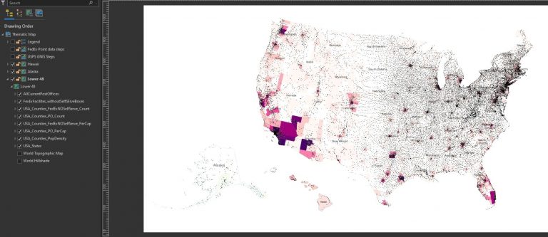
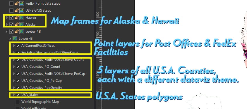
ArcGIS Pro with thematic map layout of post office points and county polygons
Layer details for Pro-to-AIX demo

More than 50,000 individual map features

  • I have a map layout set up for a typical thematic map of the US: a separate map frame for Alaska, Hawaii, and the mainland 48 states.
  • Each map frame in this layout has the following layers:
      • USA post offices (more than 32,000 points)
      • FedEx Facilities (~9,500 points – *the self-serve FedEx boxes were removed from this dataset)
      • Five separate USA counties layers, each symbolized by a different theme:
          1. Population Density
          2. Post offices per capita
          3. FedEx facilities* per capita
          4. Total post offices
          5. Total FedEx facilities*
  • A USA States layer

32,000+ Post Office points, ~9,500 FedEx points, and (5×3,141)=15,705 counties is more than 50,000 individual features.

By exporting this layout as a PDF, I would get one single layer in Illustrator with over 50,000 pieces of “artwork” without any identifying layer structure. Imagine trying to scroll through 50,000 paths (image below) just to find the counties of a specific data range for Post Offices Per Capita. The image shows the first few paths of the more-than-50,000 in a PDF export opened in Adobe Illustrator. It would take a full day to organize this export prior to styling it with efficiency. This is why you should use the AIX export option.
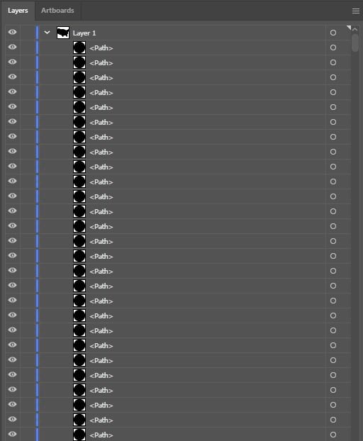
Example of unorganized layer structure in PDF export from Pro (opened in Illustrator)

Authoring a map for AIX export

There are a few things to consider when setting up an ArcGIS Pro map before sharing it as an AIX. As this feature continues grow, these considerations will change, so keep checking the product’s doc page for updates. In fact, because the AIX option is so new, the product engineers want YOU to help them make it the best for your workflow. They even made this survey for you, so that you can help influence this feature’s evolution.

Step 1 – Setting up the map in ArcGIS Pro to share as an AIX file

The Layers

I decided to create a thematic map series about U.S. Post Offices for this demo. But really, this workflow could work on any map style. In Pro, once you’ve set up your layout with all the analyses and features that you want to include, make sure the layers are visible. See the Maps for Adobe doc for more information on the Pro-to-AIX setup.

Step 2 – Share the layout as an AIX file format

When your map is ready in Pro, click the Share tab and then select “Layout” if you’re sharing the layout as an AIX, which is what I did for this map. (If you were sharing from a map tab, you would select share –> map).Make sure you’re selecting the export option of Layout, and not the print option:

Pro's share tab with layout export highlighted

Select AIX as the file format in the dialog. To add new data to the geo-spatially enabled file in Illustrator, be sure to uncheck “clip to graphics extent” to retain the coordination:
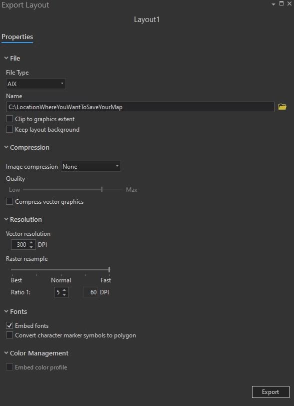
Pro share dialog settings for AIX export
To add new data to the geo-spatially enabled file in Illustrator, be sure to uncheck "clip to graphics extent" to retain the coordination.

Step 3 – Sign in to Maps for Adobe to open your AIX file

With Maps for Adobe 2.2 installed, open Adobe Illustrator, and sign in to Maps for Adobe using your ArcGIS organizational or Creator account. To open an extension in Adobe Illustrator, just go to the Windows menu, where you will then select “Extensions –> ArcGIS Maps for Adobe Creative Cloud. Once you are signed into Maps for Adobe, you can open your AIX file as an organized structured ready-to-design Illustrator file.


Selecting Extensions from Illustrator Windows menu to find the mapping plugin

The AIX layer structure in Illustrator

Parent Layers
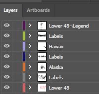
 

Parent layer organization structure in Adobe Illustrator when opening an AIX file

The image above shows the Illustrator file’s layer structure from the Pro project:

  • A parent layer for the legend, containing all the artwork making up the legend.
  • Parent layers for each map frame’s labels.
  • Parent layers for each map frame (Hawaii, Alaska, and the Lower 48 mainland states)

Sublayers

By expanding the Lower 48 parent layer, you can see the beautifully organized structure of each thematic map layer that I had in my Pro project.
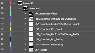
Each map layer from pro is a sublayer in Illustrator, containing all the features for that layer.

Classed category layers in Illustrator

For each layer that was symbolized by a particular class or categorized system, there will be a sublayer for each category. For example, in the image below, there is a sublayer for all the category ranges for Post Offices Per Capita. This means that I can easily select only the counties that I want and give them their own unique style in Illustrator. As you can imagine, this ready-to-go structure saves mapmakers a lot of time.
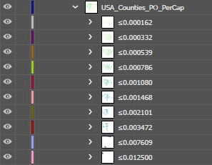
 

Each data category as an individual sublayer for easy selection in Adobe Illustrator

Geospatial AIX

As you will recall, I told you at the beginning of this post that our 2.2 release has the new geospatially enabled AIX feature. By using my ArcGIS Pro project, let’s take a look at what this means for Maps for Adobe users.

Map frames load as Mapboards

For those of you who have made a map with the traditional Maps for Adobe (making a map directly in Illustrator), you know the three basic steps:

  1. The Mapboard panel is the space where you create your map’s extent, which is called a mapboard.
  2. Once you create a mapboard, you can add layers to the mapboard in the Compilation panel.
  3. After all desired layers, labels, and geoanalyses are added, the mapboard can be downloaded as an AI file from the Compilation panel.

Now, when you open an AIX file in Illustrator, Maps for Adobe will automatically load each map frame from your ArcGIS Pro project as a mapboard in the Mapboards panel. The image below shows the Mapboards panel centered on my Lower 48 mapboard, and the dropdown illustrates each of the three mapboards that loaded when opening the AIX file. That is to say, my Lower 48, Hawaii, and Alaska map frames from my ArcGIS Pro project each have a respective mapboard. What does this mean? Well, now with my map opened in Illustrator, I can add even more layers!
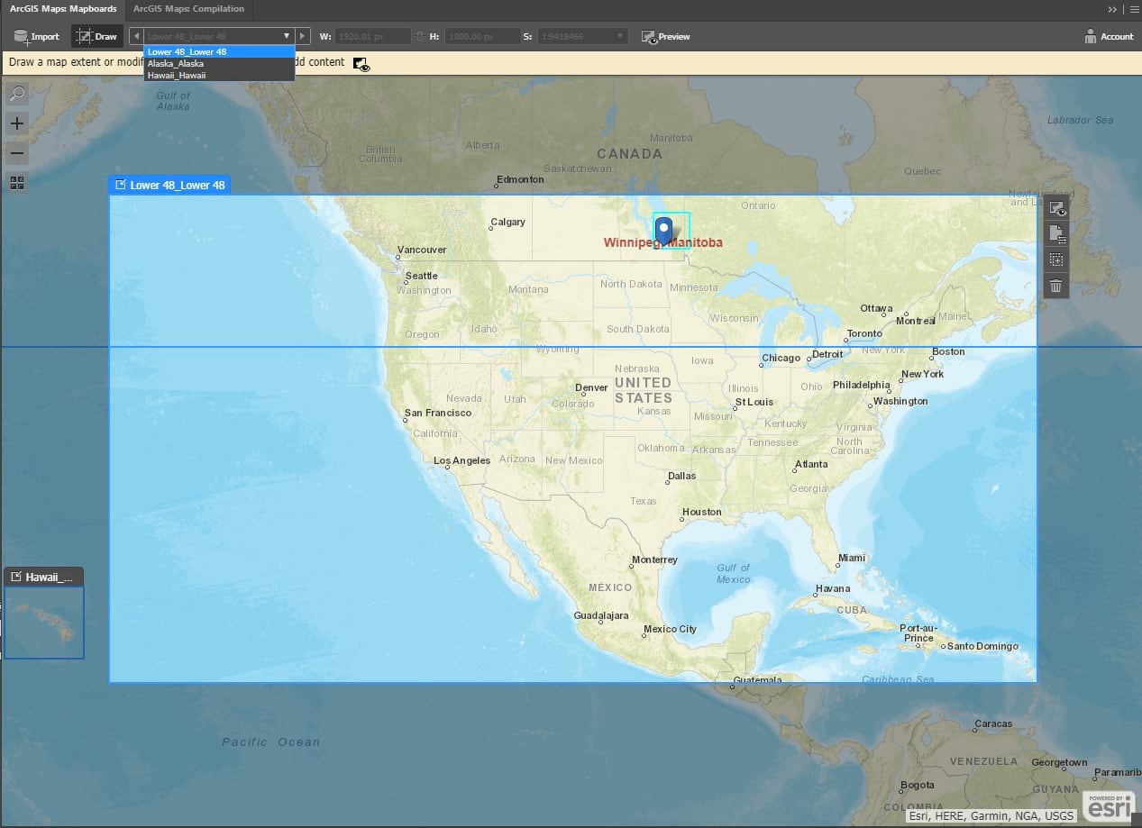
Mapboard panel with the mainland USA selected as active map

Add new layers to your AIX-generated AI file

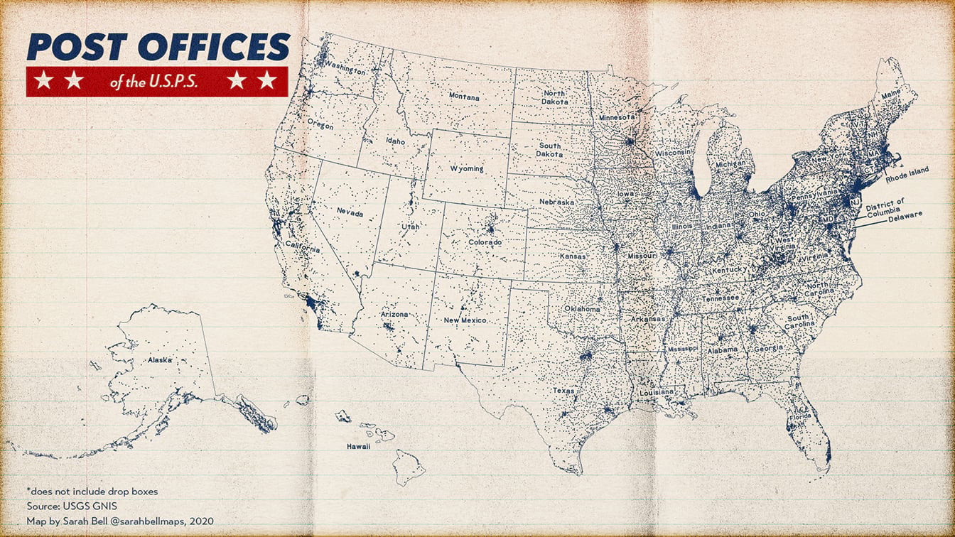
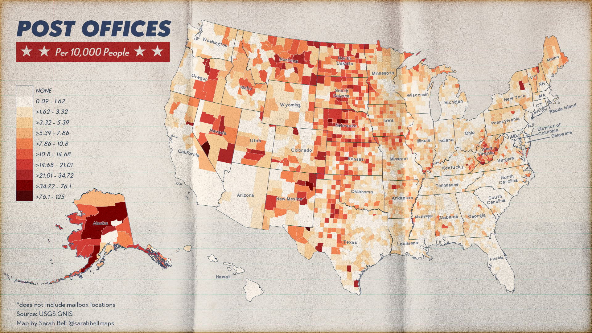
When you open the AIX file, an AI file is created that is automatically synced to Maps for Adobe, as described above. With this link, you can search ArcGIS Online, including Living Atlas and your own personal organization, for additional web maps and layers to add to your AI file. You can also sync local data to the AI file. In the image below, I am adding state boundaries from my ArcGIS organization to my Lower 48 mapboard. After adding the states layer to the mapboard, I click the sync button to add the layer to my Illustrator file. You can view some of the final Post Office maps that I made with this workflow at the end of this post.

If you want to help the product engineers grow this new AIX capability, be sure to check out their survey they made with mapmakers like you in mind.
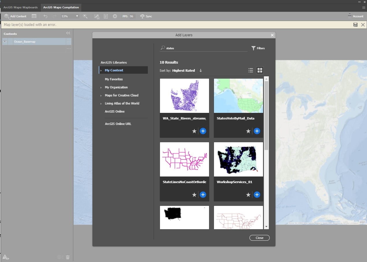
Adding new data from ArcGIS Online to the mapboard
Point map of usa post office locations
Post offices per 10,000 people

Additionally, at this month’s North American Cartographic Information Society (NACIS) annual conference, I presented the ArcGIS Maps for Adobe Creative Cloud 2.2 release (Maps for Adobe). NACIS is a 40-year-strong community of map enthusiasts who meet once a year to share and learn about cartography projects.

ABOUT THE AUTHOR

Datavisualization & mapping. When I'm not doing that, I'm rock climbing, running, and enjoying the outdoors. I post some of my work on my site, sarahbellmaps.com

CONNECT:    
Sign In to leave a comment.

Leave a Reply

 newest  oldest
Brian E
Brian E

I have map with Human Geography Dark, rotated at 29 degrees, and does not open correctly in Illustrator

NEXT ARTICLE

How to make a full-on vintage scalebar in ArcGIS Pro

Read this article