
BUILDING SITE SURVEY AND SET OUT
| Grid levels | Isometric view | Volume calculation | Contour lines | Assignment |
Two Peg Test
All instruments are subject to errors. The checking of the instrument (level) is therefore important. The main error is where the line of sight is not parallel to the horizontal line of collimation. In this case your levels will not be correct. A test for checking the level is known as the two peg test. This test determines the amount of errror and if an error occurs notif04-Jun-2020 04:59 PMid1echnician (the level must be serviced).

Figure 1
- Establish 2 points approximately 50 metres apart on level ground as shown below. Set the level half way between the 2 points.
- Take the 2 staff readings. In our example an error will exists (line of sight does not coincide with line of collimation).
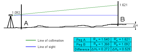
Figure 2
- Move the level as close as possible to one of the peg. (in the case above 'Peg A').
Take the 2 staff readings again. - If the difference in height is the same the level is okay. If not, as shown in the example above, the instrument needs to be serviced.
[ top of page ]
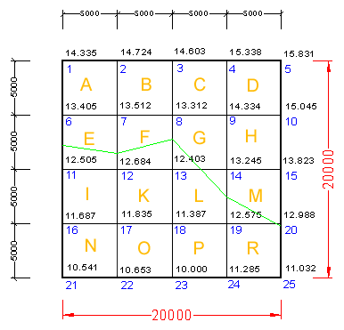
Gid leveling is used for site investigation, for drawing contour line and for the easy calculation of volumes.
The opposite figure shows a typical survey of a site using grid levels. The area of the site is divided into a number of squares 5 × 5 metres (triangels or rectangles can also be used) and levels are taken at corner points. The grid levels enable us to calculate the volume of material above or below a certain reduced level (RL) and to draw contour lines.
Figure 3The lowest level of the site is RL = 10.000 and the highst is RL = 15.831[ top of page ]
Isometric view
Figure 4 below shows the site in isometric view. As can be seen the horizontal plane at RL = 12.900 lies between the RL = 10.000 and RL = 15.831. If a house is placed on this level then some cutting and some filling would be required. However, if the FGL (finished ground level) is at RL  10.00 then all soil of the site need to be removed and if RL
  15.831 soil must be transported to the site.

Figure 4
The two grid elements F and R are truncated prism of which the area is 5 × 5 metres and the height of the prisms is approximated to the mean of the four corner heights. Therefore for the volume of the prism F is: To calculate the volume of each separate prism would take considerable time. Instead of calculating each prism we can simplify the calculation by taking the average of all levels. As can be seen prism F is surrounded by other prisms and each corner must be counted four times. The corners of the prism R on the other hand must be counted one, two and four as shown in Figure 4.
[ top of page ]
The work of getting the average of the spot levels can be simplified by the use of a suitable table as illustrated below:
 Step1
Step1
Sum up the column 5 & 6 and find the mean height (MH) by dividing the sum of the levels by the sum of the number of common points.
Step 2MH = 824.999/64 = 12.891
Find the difference between the mean height (MH) and the proposed finish ground level (FGL).
a) the difference can be positive (+ve) or negative (-ve).
b) if the mean height is greater (+ve) than the finish ground level (FGL) then it is a cut.
c) if the mean height is smaller (-ve) than the finish ground level (FGL) then it is a fill .
MH < FGL = FILL
MH > FGL = CUT
MH = FGL then CUT = FILL
Step 3
Multiply the difference (from Step 2) with the area of the lot to find the required volume.
In the isometric view the FGL = 12.900
Therefore from MH Step 2 12.891-12.900= - 0.009
The MH (12.891) < FGL (12.900) therefore some fill is required. The fill that is required is minimal because the FGL ~ MH. The amount of fill is 0.009 × 400 = 3.6 m²
[ top of page ]

A contour line is an imaginary line that links up a series of points of the same level on the earth surface. Contour lines show the vertical dimension (the third dimension) of the ground on site plans. The vertical distance separating contour lines gives an indication of the steepness of the slopes. A few simple rules for contour lines will be helpful in interpreting the vertical dimension of a building site.
Gentle slopes are represented by widely spaced contour lines.
Steep slopes are represented by closely spaced contour lines.
Figure 5
There are two ways to plot contour lines: a) by estimation b) by calculation
a) is the quickest method of plotting the contours. Estimate by visual inspection the position of a contour between two adjacent spot levels.
b) is more accurate. Similar triangle rule is used to calculate the contour line. This principle is show in Figure 6 below and is generally used for all your exercises and Assignments.

Using similar triangles:

Using the above equation the actual calculation for the contour lines 11.000 m and 11.500 m is:
 | Sometimes you know the distance for a specific point on ar grid system and want to know the reduced levels (RL's) that belongs to it. In this case use the formula to the right to find the value that need to be added to the reduced level (RL). | RL-Calculation  |
Assignment (Volumes and contour lines)
 The opposite figure shows a building site.
The lot is 50 × 40 metres and has spot levels at 10 metre intervals as indicated.
1) For this site draw all contour lines at 1 metre interval. The distance on the grid lines must be calculated using the formula for similar triangles.
2) Find the reduced level to establish a finish ground level (FGL) by utilising the cut and fill method (cut equals fill)
3) How much soil is required if the RL of the building pad (FGL) is to be 16.300. Calculate the volume.
No comments:
Post a Comment