Tuesday, December 19, 2017
Describe the different surveys to be carried out for the highway projects.
Explain the methods of transferring reduced levels from surface to underground in a tunnel setting out work.
Explain the methods of transferring reduced levels from surface to underground in a tunnel setting out work.
Friday, November 24, 2017
Types of GIS
The following GIS types are not
necessarily mutually exclusive and a GIS application can be always classified under more
than one type.
2.1 Four-dimensional GIS
While spatio-temporal georepresentations can handle two dimensions of
space and one of time, four-dimensional GIS are designed for three dimensions of space and one
of time.
2.2 Multimedia/hypermedia GIS
Multimedia/hypermedia GIS allow the user to access a wide range of georeferenced
multimedia data (e.g., simulations, sounds and videos) by selecting resources from a
georeferenced image map base. A map serving as the primary index to multimedia data in a
multimedia geo-representation is termed a hypermap. Multimedia and virtual georepresentations
can be stored either in extended relational databases, object databases or in
application-specific data stores.
2.3 Web GIS
Widespread access to the Internet, the ubiquity of browsers and the explosion of
commodified geographic information has made it possible to develop new forms of multimedia
geo-representations on the Web.
Many current geomatics solutions are Web-based overtaking the traditional Desktop
environment and most future ones are expected to follow the same direction.
2.4 Virtual Reality GIS
Virtual Reality GIS have been developed to allow the creation, manipulation
and exploration of geo-referenced virtual environments, e.g., using VRML modelling
(Virtual Reality Modelling Language). Virtual Reality GIS can be also Web-based. Applications
include 3D simulation for planning (to experiment with different scenarios).
Monday, October 30, 2017
Different Types of Levels Used for Leveling in Surveying
Different Types of Levels Used for Leveling in Surveying
There are various types of levels for leveling in surveying. The process of measuring vertical distances in surveying is called leveling.
To perform leveling, we need some level instruments to focus or to read the object. Nowadays, the technology also introduced in surveying and so many easy measuring instruments are designed. Here we discuss about the different levels used in leveling.
Types of Levels Used in Leveling
Following are the types of different levels used for leveling in surveying:
Dumpy level
Y level
Cushing’s level
Tilting level
Cooke’s reversible level
Automatic level
Dumpy Level
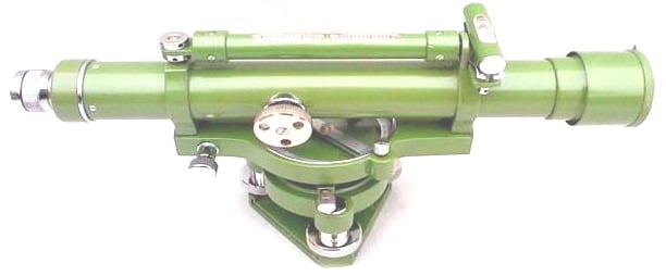
Dumpy level is the most commonly used instrument in leveling. In this level the telescope is restricted against movement in its horizontal plane and telescope is fixed to its support. A bubble tube is provided on the top of the telescope.
But however, the leveling head can be rotated in horizontal plane with the telescope. The telescope is internal focusing telescope is a metal tube contains four main parts as given below.
Objective lens
Negative lens
Diaphragm
Eye-piece
Objective Lens
Objective lens should be made as the combination of crown glass and flint glass. Because of this some defects like spherical aberration and chromatic aberration can be eliminated. A thin layer coating which has smaller refractive index than glass is provided on the objective lens to reduce the loss due to reflection.
Negative Lens
Negative lens located co axial to the objective lens. So, the optical axis for both lenses is same.
Diaphragm
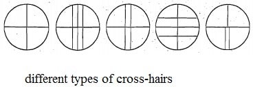
Diaphragm is fitted inside the main tube which contains cross hairs (vertical and horizontal) and these are adjusted by capstan headed screws. The cross hairs are made of dark metal as filament wires which are inserted in diaphragm ring in exact position. For stadia leveling purposes, extra two horizontal cross hairs are provided above and below the horizontal wire.
Eyepiece
Eyepiece lens enable the ability to sight the object together with cross hairs. The image seen through eye piece is magnified and inverted. Some eyepieces erect the image into normal view and those are called as erecting eyepieces.
Y Level
Y level or Wye-level consists y-shaped frames which supports the telescope. Telescope cane be removed from the y-shaped supports by releasing clamp screws provided. These y-shaped frames are arranged to vertical spindle which helps to cause the rotation of telescope.
Compared to dumpy level, adjustments can be rapidly tested in y- level. But, there may be a chance of frictional wear of open parts of level.
Cushing’s Level
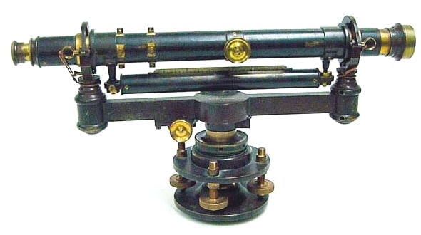
In case of Cushing’s level, the telescope is restricted against rotation in its longitudinal axis and it is non-removable. But, the object end and eye piece end can be interchangeable and reversible.
Tilting Level
Tilting level consist a telescope which enabled for the horizontal rotation as well as rotation about 4 degree in its vertical plane. Centering of bubble can be easily done in this type of level. But, for every setup bubble is to be centered with the help of tilting screw.
The main advantage of tilting level is it is useful when the few observations are to be taken with one setup of level.
Cooke’s Reversible Level
Cooke’s reversible level is the combination of dumpy level and y-level. In this instrument, the telescope can be reversed without rotation the instrument. Collimation error can be eliminated in this case because of bubble left and bubble right reading of telescope.
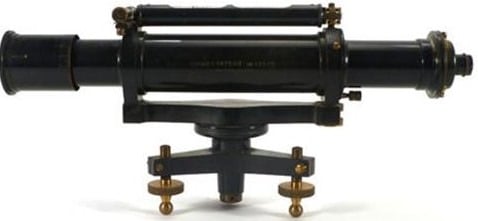
Automatic Level
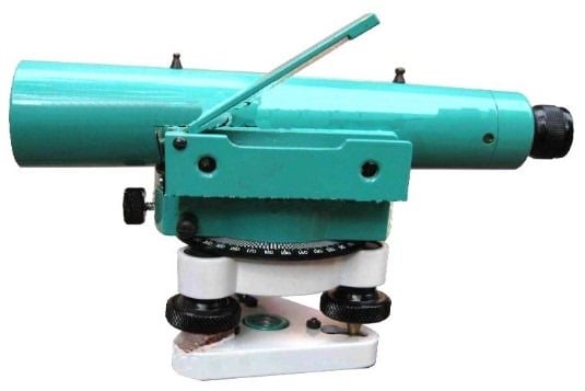
Automatic level is like the dumpy level. In this case the telescope is fixed to its supports. Circular spirit can be attached to the side of the telescope for approximate leveling. For more accurate leveling, compensator is attached inside the telescope.
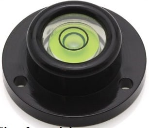
Compensator can help the instrument to level automatically. Compensator is also called as stabilizer which consists two fixed prisms and it creates an optical path between eye piece and objective.
Due to the action of gravity, the compensator results the optical system to swing into exact position of line of sight automatically. But before the process of leveling, compensator should be checked.
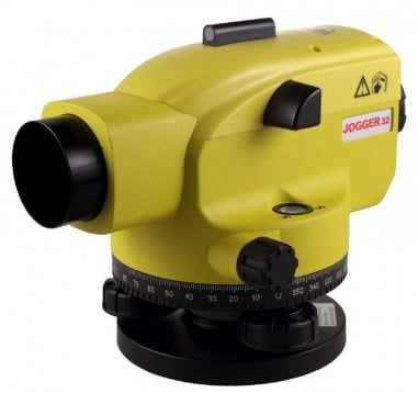
To check the compensator, just move the foot screws slightly if the leveling staff reading remains constant then compensator is perfect. If it is not constant, then tap the telescope gently to free the compensator. Automatic level is also called as self-adjusting level.
Types of Leveling Methods used in Surveying
Types of Leveling Methods used in Surveying
There are various types of leveling used in surveying for measurement of level difference of different points with respect to a fixed point. This is useful in various civil engineering construction works where levels of different structures need to be maintained as per drawing.
What Is Leveling?
Leveling is a branch of surveying in civil engineering to measure levels of different points with respect to a fixed point such as elevation of a building, height of one point from ground etc.
Types of Leveling in Surveying
Direct leveling
Trigonometric leveling
Barometric leveling
Stadia leveling
Direct Leveling
It is the most commonly used method of leveling. In this method, measurements are observed directly from leveling instrument.
Based on the observation points and instrument positions direct leveling is divided into different types as follows:
Simple leveling
Differential leveling
Fly leveling
Profile leveling
Precise leveling
Reciprocal leveling
Simple Leveling
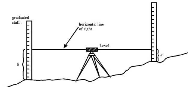
It is a simple and basic form of leveling in which the leveling instrument is placed between the points which elevation is to be find. Leveling rods are placed at that points and sighted them through leveling instrument. It is performed only when the points are nearer to each other without any obstacles.
Differential Leveling
Differential leveling is performed when the distance between two points is more. In this process, number of inter stations are located and instrument is shifted to each station and observed the elevation of inter station points. Finally difference between original two points is determined.

Fly Leveling
Fly leveling is conducted when the benchmark is very far from the work station. In such case, a temporary bench mark is located at the work station which is located based on the original benchmark. Even it is not highly precise it is used for determining approximate level.
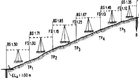
Profile Leveling
Profile leveling is generally adopted to find elevation of points along a line such as for road, rails or rivers etc. In this case, readings of intermediate stations are taken and reduced level of each station is found. From this cross section of the alignment is drawn.

Precise Leveling
Precise leveling is similar to differential leveling but in this case higher precise is wanted. To achieve high precise, serious observation procedure is performed. The accuracy of 1 mm per 1 km is achieved.
Reciprocal Leveling
When it is not possible to locate the leveling instrument in between the inter visible points, reciprocal leveling is performed. This case appears in case of ponds or rivers etc. in case of reciprocal leveling, instrument is set nearer to 1st station and sighted towards 2nd station.

Trigonometric Leveling
The process of leveling in which the elevation of point or the difference between points is measured from the observed horizontal distances and vertical angles in the field is called trigonometric leveling.
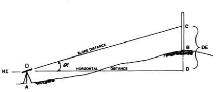
In this method, trigonometric relations are used to find the elevation of a point from angle and horizontal distance so, it is called as trigonometric leveling. It is also called as indirect leveling.
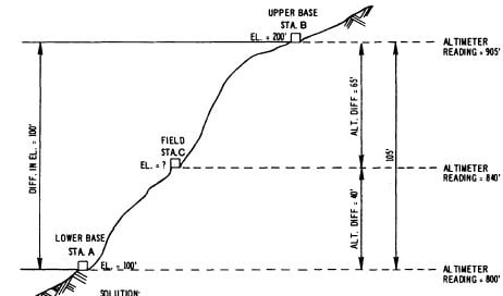
Barometric Leveling
Barometer is an instrument used to measure atmosphere at any altitude. So, in this method of leveling, atmospheric pressure at two different points is observed, based on which the vertical difference between two points is determined. It is a rough estimation and used rarely.
Stadia Leveling
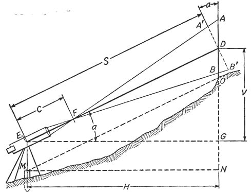
It is a modified form of trigonometric leveling in which Tacheometer principle is used to determine the elevation of point. In this case the line of sight is inclined from the horizontal. It is more accurate and suitable for surveying in hilly terrains.
TOTAL STATION –OPERATION, USES & ADVANTAGES
TOTAL STATION –OPERATION, USES & ADVANTAGES
What is a Total Station?
Total station is a surveying equipment combination of Electromagnetic Distance Measuring Instrument and electronic theodolite. It is also integrated with microprocessor, electronic data collector and storage system. The instrument can be used to measure horizontal and vertical angles as well as sloping distance of object to the instrument.
Capability of a Total Station:
Microprocessor unit in total station processes the data collected to compute:
Average of multiple angles measured.
Average of multiple distance measured.
Horizontal distance.
Distance between any two points.
Elevation of objects and
All the three coordinates of the observed points.
Data collected and processed in a Total Station can be downloaded to computers for further processing.
Total station is a compact instrument and weighs 50 to 55 N. A person can easily carry it to the field. Total stations with different accuracy, in angle measurement and different range of measurements are available in the market. Figure below shows one such instrument manufactured by SOKKIA Co. Ltd. Tokyo, Japan.

Fig: Parts of total station
Brief Description of Important Operations of Total Station:
Distance Measurement:
Electronic distance measuring (EDM) instrument is a major part of total station. Its range varies from 2.8 km to 4.2 km. The accuracy of measurement varies from 5 mm to 10 mm per km measurement. They are used with automatic target recognizer. The distance measured is always sloping distance from instrument to the object. Angle Measurements: The electronic theodolite part of total station is used for measuring vertical and horizontal angle. For measurement of horizontal angles any convenient direction may be taken as reference direction. For vertical angle measurement vertical upward (zenith) direction is taken as reference direction. The accuracy of angle measurement varies from 2 to 6 seconds.
Data Processing :
This instrument is provided with an inbuilt microprocessor. The microprocessor averages multiple observations. With the help of slope distance and vertical and horizontal angles measured, when height of axis of instrument and targets are supplied, the microprocessor computes the horizontal distance and X, Y, Z coordinates. The processor is capable of applying temperature and pressure corrections to the measurements, if atmospheric temperature and pressures are supplied.
Display:
Electronic display unit is capable of displaying various values when respective keys are pressed. The system is capable of displaying horizontal distance, vertical distance, horizontal and vertical angles, difference in elevations of two observed points and all the three coordinates of the observed points.
Electronic Book:
Each point data can be stored in an electronic note book (like compact disc). The capacity of electronic note book varies from 2000 points to 4000 points data. Surveyor can unload the data stored in note book to computer and reuse the note book.
Use of Total Station
The total station instrument is mounted on a tripod and is levelled by operating levelling screws. Within a small range instrument is capable of adjusting itself to the level position. Then vertical and horizontal reference directions are indexed using onboard keys. It is possible to set required units for distance, temperature and pressure (FPS or SI). Surveyor can select measurement mode like fine, coarse, single or repeated.
When target is sighted, horizontal and vertical angles as well as sloping distances are measured and by pressing appropriate keys they are recorded along with point number. Heights of instrument and targets can be keyed in after measuring them with tapes. Then processor computes various information about the point and displays on screen.
This information is also stored in the electronic notebook. At the end of the day or whenever electronic note book is full, the information stored is downloaded to computers.
The point data downloaded to the computer can be used for further processing. There are software like auto civil and auto plotter clubbed with AutoCad which can be used for plotting contours at any specified interval and for plotting cross-section along any specified line.
Advantages of Using Total Stations
The following are some of the major advantages of using total station over the conventional surveying instruments:
Field work is carried out very fast.
Accuracy of measurement is high.
Manual errors involved in reading and recording are eliminated.
Calculation of coordinates is very fast and accurate. Even corrections for temperature and pressure are automatically made.
Computers can be employed for map making and plotting contour and cross-sections. Contour intervals and scales can be changed in no time.
However, surveyor should check the working condition of the instruments before using. For this standard points may be located near survey office and before taking out instrument for field work, its working is checked by observing those standard points from the specified instrument station.
Surveying Principles and Methods in Civil Engineering
Surveying Principles and Methods in Civil Engineering
Surveying is the process of determining relative positions of different objects on the surface of the earth by measuring horizontal distances between them and preparing a map to any suitable scale.
Measurements are taken in horizontal plane only. Surveying is the art of determining the relative positions of points on, above or beneath the surface of the earth by means of direct or indirect measurements of distance, direction and elevation.
Leveling is a branch of surveying the object of which is to find the elevations of points with respect to a given or assumed datum and to establish points at a given elevation or at different elevations with respect to a given or assumed datum.
Survey is performed to prepare a map of relative positions on surface of the earth. It shows the natural feature of a country such as towns, villages, roads, railways, etc. They may also include details of different engineering works such as bridge, canal, dam etc.
Before commencement of any major engineering project, survey is carried out to determine the location of site and its surrounding. To understand the topography of the site and natural resource availability. Survey is carried out to prepare the cadastral map showing property boundaries.
Principles of Surveying
The fundamental principle upon which the various methods of plane surveying are based can be stated under the following two aspects.
Location of a point by measurement from two points of reference
According to this principle, the relative position of a point to be surveyed should be located by measurement from at least two points of reference, the positions of which have already been fixed.
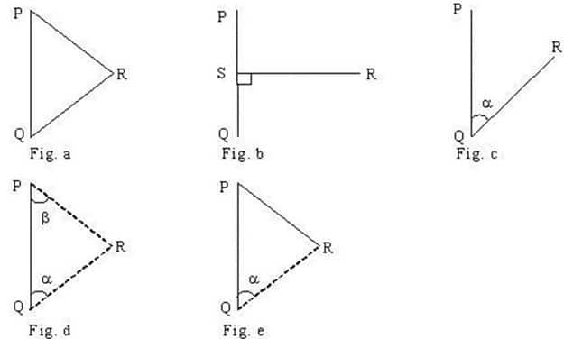
If P and Q are the two reference points on the ground, any other point, such as R, can be located by any of the direct methods shown in the above figures. But, although a single method is sufficient to locate the relative position of ‘R’ with respect to reference points P and Q, it is necessary to adopt at least any two methods to fix the position of point ‘R’.
While the measurements made in the either of the first method or second method will be helpful in locating the point ‘R’, the measurements made in the other method will act as a check.
Working from whole to part

According to this principle, it is always desirable to carryout survey work from whole to part. This means, when an area is to be surveyed, first a system of control points is to be established covering the whole area with very high precision. Then minor details are located by less precise methods.
The idea of working this way is to prevent the accumulation of errors and to control and localize minor errors which, otherwise, would expand to greater magnitudes if the reverse process is followed, thus making the work uncontrolled at the end.
Method of Surveying in Civil Engineering
Method of Surveying in Civil Engineering
Primary types of Surveying are:
Plane surveying
Geodetic surveying
1. Plane surveying
Plane surveying is conducted by state agencies as well as private agencies. As we know earth is spherical in shape but its diameter is big enough to consider plane in small dimensions. It is that type of surveying in which the mean surface of the earth is considered as a plane and the spheroidal shape is neglected. All triangles formed by survey lines are considered as plane triangles. The level line is considered as straight and plumb lines are considered parallel. Plane surveying is done of the area of survey is less than 250 km2.
2. Geodetic surveying
Geodetic survey is conducted by survey department of the country. It is that type of surveying in which the curved shape of the earth is taken in to account. The object of geodetic survey is to determine the precise position on the surface of the earth, of a system of widely distant points which form control stations in which surveys of less precision may be referred. . Line joining two points is considered as curved line and angles are assumed as spherical angles. It is carried out if the area exceeds over 250 km2.
Secondary classification of Surveying
Surveys may be classified based on the nature of the field of survey, object of survey and instruments used.
1) Surveying based on Nature of Survey
a) Topographical Surveys
They are carried out determine the position of natural features of a region such as rivers, streams, hills etc. and artificial features such as roads and canals. The purpose of such surveys is to prepare maps and such maps of are called topo-sheets.
b) Hydrographic Survey
Hydro-graphic survey is carried out to determine M.S.L. (Mean Sea Level), water spread area, depth of water bodies, velocity of flow in streams, cross-section area of flow etc.
c) Astronomical Survey
The Astronomical Survey is carried out to determine the absolute location of any point on the surface of earth. The survey consists of making observations to heavenly bodies such as stars.
d) Engineering Survey
This type of survey is undertaken whenever sufficient data is to be collected for the purpose of planning and designing engineering works such as roads, bridges and reservoirs.
e) Archeological Survey
This type of survey is carried out to gather information about sites that are important from archeological considerations and for unearthing relics of antiquity.
f) Photographic Survey
In this type of survey, information is collected by taking photographs from selected points using a camera.
g) Aerial Survey
In this type of survey data about large tracks of land is collected by taking photographs from an aero-plane.
h) Reconnaissance Survey
In this type of survey, data is collected by marking physical observation and some measurements using simple survey instruments.
2) Surveying based on Type of Instruments
a) Chain Surveying
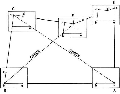
Chain surveying is the basic and oldest type of surveying. The principle involved in chain survey is of triangulation. The area to be surveyed is divided into a number of small triangles. Angles of triangles must not be less than 30 degree and greater than 120 degree. Equilateral triangles are considered to be ideal triangles. No angular measurements are taken, tie line and check lines control accuracy of the work.
This method is suitable on level ground with little undulations and area to be survey is small.

b) Compass Surveying
Compass survey uses the principle of traversing. This method does not requires the need to create triangles. It uses a prismatic compass for measuring magnetic bearing of line and the distance is measured by chain. A series of connecting lines is prepared using compass and measuring distances using chain. Interior details are located using offset from main survey lines.
They suitable for large area surveying crowded with many details. It can be used to survey a river course.

The principle of plane table survey is parallelism. They are plotted directly on paper with their relative position. The rays are drawn from station to object on ground. The table is placed at each of the successive station parallel to the position of the last station.
They are basically suitable for filling interior detailing and is recommended when great accuracy is not required.
d) Theodolite Surveying
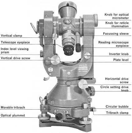
The theodolite is an instrument used mainly for accurate measurement of the horizontal and vertical angles. They are accurate to measure up to 10″ or 20″ angles.
Theodolite can be used to measure:
Horizontal angles
Vertical angles
Deflection angle
Magnetic bearing
Horizontal distance between two points
Vertical height between two points
Difference in elevation
Nowadays theodolite is shadowed and replaced by the use of Total Station which can perform the same task with greater ease and accurate results
e) Tacheometric Surveying
Tacheometry is a branch of surveying in which horizontal and vertical distances are determined by taking angular observations with an instrument known as a tacheometer. Tacheometer is nothing but a transit theodolite fitted with a stadia diaphragm and an anallatic lens. There is no need for chaining in such survey. The principle of Tacheometer is based on property of isosceles triangle, where ratio of the distance of the base from the apex and the length of the base is always constant.
Different form of stadia diaphragm commonly used:

f) Photographic Surveying
Photographic survey is based on technique of taking photographs from different angle to prepare topographic details with relative high speed.
Friday, September 29, 2017
Saturday, September 9, 2017
Thursday, August 10, 2017
20 REASONS WHY MASTURBATION IS WRONG
By Sunday Adelaja
In one of my ‘Ask Pastor Sunday’ sessions, I was asked about the question of masturbation. My initial understanding was that I must give people some relief from the feelings of guilt after the practice of masturbation. So I tried to comfort young people who don’t wish to practice actively the act of masturbation, but yet find themselves having wet dreams.
A wet dream is an erotic dream that causes involuntary ejaculation of semen. This act that happens to almost all men, tells us about the nature of men. It is a proof that the act of releasing semen is natural. It also explains why men are more sexually driven than the women.
When you understand wet dreams it is also easy to understand why masturbation is so popular with men. The way the man is wired is that his semen gathers with time in his sperm bag either he likes it or not they need to be released or used up one way or the other. That is why not all release of semen should be considered as sinful, especially in the case of wet dreams. In my question and answer sessions, I was trying to comfort young men that find themselves in a similar situation not to live in the resultant process of blame or self-condemnation that follows the involuntary ejaculation of semen.
Nevertheless, why do most Christians see masturbation as a sinful act? This was yet another question that followed the previous one in another of my question and answer sessions. I was directly challenged to answer if masturbation is a sin or not. My explanation was that when most people masturbate they have to imagine an image or a partner in their mind, which equals to what Jesus called adultery in the book of Matthew.
“You have heard that it was said to those of old, ‘You shall not commit adultery.’ But I say to you that whoever looks at a woman to lust for her has already committed adultery with her in his heart.” Matt 5:27-28
When a man lusts in his heart after a woman, he has already committed adultery with her even though he has not physically slept with her. That mental adultery goes along side with masturbation.
The reason why I have decided to write this more elaborate article about why masturbation is wrong is that some people who are not Christians and don’t believe the authority of the Bible asked the question that apart from the Bible saying masturbation is a sin, is there any other thing that proves that the act itself is wrong?
My aim, therefore, today is to give reasons why I believe that masturbation is still wrong even if we are not considering what Jesus said about adultery in the heart. I want to point out to all my readers that there are enough reasons to believe that masturbation is wrong even without considering the fact that it is sinful.
20 REASONS WHY MASTURBATION IS WRONG.
Also read this: Important Facts You Need To Know About Spirit Husband And Spirit Wife
1. Loss of interest in marriage:
Most men that actively practice the act of masturbation will in time lose the taste for the institution of marriage.
2. Loss of life focus:
The men that actively masturbate tend to think about it most of the time. It is as bad as according to some psychologist, there are men who think about masturbating every 5 minutes making them lose focus on the most important things in life. A man’s thoughts are supposed to be predominantly about his life’s goals, missions and purposes.
3. Feelings of inferiority complex:
In most cases when men practice masturbation on regular basis, they develop feelings of inferiority complex. They tend to think that they are not normal and in some cases, they think they are the only ones suffering from this addiction. They think others are normal while they are not.
4. Late marriages:
They are normally late marriages among people who are addicted to practising masturbation for a long time. They find it difficult to morally get themselves equipped and ready not seeing much need for it. In some cases, they are afraid of the responsibilities that come with marriage.
5. Unhealthy sexual fantasies:
Most people who are involved in masturbation cannot really do without fantasizing. This process of fantasizing could be as gory and pervasive in the mind as it could get. This becomes a problem in marriage when a married man is sleeping with his wife yet in his fantasies he is actually not seeing his wife but other women.
6. The flesh is insatiable:
People involved in masturbation sooner or later discover that the hunger for sexual satisfaction is insatiable. Hence the process of seeking for pleasure always lands such an individual in the most sordid practices of sexual pervasion including soliciting the services of prostitutes and escorts.
7. It brings sexual pervasion into marriage:
For a married man who , to masturbating before marriage, the degradation could continue to the extent of him not being able to be sexually aroused by his spouse. In which case most men have to result to watching pornographic films and pictures while they make love to their wives otherwise they will not be able to get themselves aroused.
8. Masturbation could lead to swinging in marriage:
The height of sexual pervasion that results from masturbation is what is called swinger parties when men who are no more aroused by their partners go to the extent of engaging in sex with other married couples. Even going to the extent of arranging orgy parties for it.
9. Masturbation could lead to sexual fetishism:
A lot of young men go about stealing ladies underwear or getting close to women private belongings so as to use them as an act of sexual gratification. a is as a result of a long practice of self-gratification through masturbation that now looks for a more outward expression. , normally happens to men that lack the guts and boldness to approach a lady. It is a form of addiction.
10. Pornographic addiction:
Most people who practice masturbation end up becoming addicted to pornography because it provides secrecy and it allows for a faster process of fantasy and ejaculation. The problem is that it becomes addictive sooner or later.
Also read this: What Saraki Stopped Doing Will Leave You Speechless
11. Masturbation leads to horrible sexual pervasion:
People who start out with masturbation have been found to be caught in rape, sex with animals, sadism, sadomasochism and other unthinkable acts. a is because the flesh can never be satisfied. The fantasy and pursuit of sexual satisfaction are endless.
12. Masturbation leads to prostate related diseases:
Most people who are actively involved in masturbation get complications in their later years, because of different complications they have with their health after the age of 40. It might not necessarily lead to prostate cancer for everybody, but it gives enough health concerns to be worried about.
13. Selfishness and egocentrism in marriage:
A person that is used to satisfying himself sexually through masturbation continues to do that even after he is married. The wife will be constantly dissatisfied because the husband is not used to satisfying others but himself.
14. Premature ejaculation:
One of the main problems in marriage for people who have been involved in masturbation is premature ejaculation. Why that is a problem is that when a man suffers from premature ejaculation, the woman in most cases remains unsatisfied which could lead to complications in the marriage relationship.
15. Erectile dysfunction:
When someone engages in masturbation long enough, it gets to a point when you don’t really need an erection to ejaculate and once a man ejaculates he is satisfied but in marriage, this becomes a problem because an erection is necessary to satisfy a partner sexually. It is also necessary for reproduction.
16. Feelings of Guilt and self-condemnation:
One of the most horrible consequences of masturbation is that most people who engage in it experience feelings of guilt and self-condemnation on a regular basis, which is also an indication to us that it is not natural to live a life of masturbation.
17. Depression and gloominess:
Masturbation often results in feelings of depression and gloominess. Most people who are involved in masturbation become moody and closed because they are afraid of sharing their experience with people because of the fear of condemnation and being misunderstood.
18. Inability to build a healthy relationship with the opposite sex:
Most people who are involved in masturbation are so used to living within themselves, they reach agreements with themselves that they often don’t know how to build the complicated relationship with the opposite sex. In a relationship you need to constantly find out what the other person’s interest is. This could lead to men preferring not to marry or even to divorce after marriage.
19. Social and societal awkwardness:
Most such men feel awkward and unaccepted in the society and among their peers. They feel out of place if they don’t have a girlfriend or if they don’t marry at a certain age or they are uninterested in woman. On the other hand, they might feel they are under pressure from the society to get a wife even though they don’t have the interest. They might be pushed into marrying to make children even though they don’t have the love for their partner. They have all sorts of awkwardness due to masturbation.
Also read this: 7 signs that you have an excellent husband
20. Lack of strong will:
The problem of masturbation is an affirmation of the fact that a man has stopped fighting. It is an acceptance of defeat. In most cases when you accept defeat in a particular area of your life, it could go a long way to affecting you in other areas. It now becomes easier to give up rather than to fight.
Conclusion:
Ladies and gentlemen, allow me to state here that by this article I am by no means trying to condemn anyone. On the opposite, my intention is to give a helping hand to all men and women that are faced with this challenge. The reason I can authoritatively write about this subject is due to the fact that I was a victim of sexual addiction especially masturbation. I can testify to the fact that God can give victory to anyone that so desires.
I have written a book that is available on Amazon that is called Living Sexually Free for those that are interested, you can get yourself a copy. I also want to let you know that if you are reading this article, you should be on the lookout for another article which is going to be about concrete steps to overcome masturbation.
Meanwhile, I will wish to encourage every man or family that is struggling with this habit to start by stopping to condemn yourself and each other. Make sure you shift your attention from the dominance of masturbation into more relevant topics of life like goals, purposes, missions, etc.
I also want to say that even when you are already free from masturbation, you should not assume that there would not be times when you will experience a low point. The most important thing to fight against becoming addicted. That is you don’t practice it on a permanent or constant basis. If it is only a matter of occasional failure, simply get up, dust yourself off and keep moving. Move on towards your goals, targets and destination in life. When you keep on fighting that way soon you will find out that you are experiencing more and more victory until you eventually discover that it is no more a question of worry or concern in your life.
Spend less time deliberating within yourself or fighting in your mind. Focus on your love for God and on building a closer relationship with your creator. It is my belief that love is stronger than any sin. If your love for God is stronger than for any habit, you are in a safe place.
Source: Sunday Adelaja’s
Monday, August 7, 2017
5 Things Successful People Do (Every Day)
Do you ever wish that you were a little bit more
successful than you are right now?
The truth is… many people do! And of course, you most
definitely can be :)
However, there are certain things that successful people
do every day to create more success and happiness in
their lives.
Want to know what they are?
To create more success in your life, try implementing
these 5 simple tips:
Tip 1- Start Your Day Early.
I know what you’re thinking - you do your best work at
night or you love sleeping in? Well, research shows that
morning people are more proactive and more
productive. They use this time of the day to focus on the
things that have priority, and therefore they accomplish
more!
Tip 2- Move Your Body!
Let’s face it, when we move and stretch our bodies, we
instantly feel better. This is because movement triggers
our body to release stress and endorphins. Successful
people know this and they take their health seriously!
Whether it’s doing a yoga class, hitting the gym or
walking your dog, make sure you set aside some time
each day to be active.
Tip 3- Make Time For Yourself And Your Loved
Ones.
Successful people value the importance of setting aside
some time for themselves, disconnecting from all
technology and enjoying the activities they love most,
like reading a book, listening to music or spending
quality time with their friends and family. They know that
this time is as valuable as working, as it allows them to
energize and replenish their mind and soul.
Tip 4- Take Ownership Of Your Own Happiness.
For successful people, happiness is a choice, not an
external circumstance. They find joy in the simplest
things in life - a smile, sunshine, a conversation. They
tend to see the positive in every situation and they treat
life as the ultimate gift! So make the decision to be
happy right now! :)
Tip 5- Plan ahead.
To maximize their potential, successful people map out
their days, have short-term goals and they also hold a
clear vision of what they want out of life!
Now as you can see, this is not weird science. It just
takes perseverance to incorporate these small steps
into your life in order to make a positive change.
If you can’t follow all of them right away, don’t stress out,
take baby steps and incorporate 1 tip each week until it
becomes a habit.
Sunday, July 30, 2017
DO NOT GET MARRIED Unless You Ask Your Partner These
DO NOT GET MARRIED Unless You Ask Your Partner These 11 Questions!
Friday, July 21, 2017
Which of God’s attributes are above all others?
Answer: The question of which of God’s attributes are highest or most important or “above” the others must be answered in two parallel modes. One possible answer differentiates between the attributes of God that are more important for us to understand; but we must also consider whether or not some attributes of God are more important for Him, in reality. Interestingly, when we look at the attributes of God, we find they are all unchangeably perfect, so there is no practical difference in their importance—at least not to God. However, from a human viewpoint, the way we understand God’s qualities has to come in a certain order.
In order to be truly “infinitely” perfect, a being has to be perfect in all qualities. Attributes such as omnipotence and omniscience can only exist in cooperation with each other. For example, a being could not have all possible power unless he also has all possible knowledge. He could not be all-knowing unless he was all-present. And so on and so forth. For this reason, God’s attributes cannot be ranked on a scale of importance as if some were more critical than others to who God is. All of God’s qualities are equally perfect, equally “infinite,” and equally ranked.
At the same time, human beings are not infinite, nor are we perfect. Our understanding has to come in steps and stages. For this reason, certain attributes of God must be understood before we can properly appreciate the others. When all is said and done, the starting point for understanding who God is, from a human perspective, is His holiness (see Isaiah 6:3). God’s holiness means that He is set apart from mankind, that He is something other than we are, in a radical and fundamental way. He is perfection, without a hint of unrighteousness. Before anything else about God makes sense, we must understanding that God is holy—without recognizing this uniqueness, none of His other qualities make sense.
More generally, we need to understand attributes of God that are “beyond” mankind before we can make sense of those more connected to human experience. God’s holiness, sovereignty, and omnipotence, for example, are crucial foundations for our understanding of His other qualities such as love and justice. As pointed out before, God’s perfection ensures none of those qualities are “more” or “less” present in God than the others. But, in order to grasp God to the extent the human mind is able, we can arrange those qualities in a certain logical order. That begins with His holiness, extends to His power (omnipotence, sovereignty, etc.), and then to His personality (love, mercy, justice, etc.).
Sunday, June 11, 2017
Traverse Correction - Bowditch Method
Traverse Correction - Bowditch Method
- Closed Traverse:
When a series of connected lines form a closed circuit, ie. When the finishing point coincides with the starting point, then it is called as a closed traverse. These closed traverse surveys has many applications like fixing the boundaries of ponds, forests etc..
- Open traverse :
When a sequence of connected lines extends along a general direction and does not return to the starting point, it is known as ‘open traverse’ or ‘unclosed traverse’.
- GPS pair points are fixed at a convenient distance, approximately about 3 to 5km. Care has to be taken that the pair of GPS points is fixed at a reliable distance (at least 60m is advised for better results) and on good monuments. These points are fixed in such a way that they are clearly inter visible and should cater for placing the total station firmly on the GPS stations,
- Total station is to be checked for its calibration, prism constants for the prisms to be set in the instrument to avoid errors.
- Total station is then used to conduct the traverse between the GPS points. This type of traverse ensures that the survey is started from a known pair of points and is closed on known pair of points. Care has to be taken that the last bearing is also taken for correcting the misclosures.
- There are several methods to correct the traverse misclosures. However, in most of the cases Bowditch rule is considered to be most reliable. The other methods like transit method, Crandall method, Least Square Methods are used very rarely. The most accurate method which is known as a misclosures correction by the least square method is used when the accuracy required is very high. This method finds itself applicable in the projects like tunnel works.
- Bowditch Rule
- Whole Circle Bearing
- Quandrantal Bearing
TOTAL STATION TRAVERSING ADJUSTMENT BY BOWDITCH METHOD
TOTAL STATION TRAVERSING ADJUSTMENT BY BOWDITCH METHOD
PROCEDURE FOR TRAVERSE CALCULATIONS
- Adjust angles or directions
- Determine bearings or azimuths
- Calculate and adjust latitudes and departures
- Calculate rectangular coordinates
DETERMINING BEARINGS OR AZIMUTHS
- Requires the direction of at least one line within the traverse to be known or assumed
- For many purposes, an assumed direction is sufficient
- A magnetic bearing of one of the lines may be measured and used as the reference for determining the other directions
- For boundary surveys, true directions are needed
LATITUDES AND DEPARTURES

Line | Dir | Deg | Min | Sec | Dir | Degrees | Length | Cumulative Length | Azimuthal Angles | Departure | Latitude |
AB | N | 26 | 10 | 0 | E | N26.167E | 285.1 | 285.1 | 26.167 | +125.726 | +255.881 |
BC | S | 75 | 25 | 0 | E | S75.417E | 610.45 | 895.55 | +104.583 | +590.784 | -153.700 |
CD | S | 15 | 30 | 0 | W | S15.5W | 720.48 | 1616.03 | +195.500 | -192.540 | -694.276 |
DE | N | 1 | 42 | 0 | W | N1.7W | 203 | 1819.03 | +358.300 | -6.022 | +202.911 |
EA | N | 53 | 0 | 0 | W | N53W | 647.02 | 2466.05 | +307.000 | -516.733 | +389.386 |
CLOSURE OF LATITUDES AND DEPARTURES
- The algebraic sum of all latitudes must equal zero or the difference in latitude between the initial and final control points
- The algebraic sum of all departures must equal zero or the difference in departure between the initial and final control points
ADJUSTMENT OF LATITUDES AND DEPARTURES
Line | Dir | Deg | Min | Sec | Dir | Length | Cumulative Length | Azimuthal Angles | Departure | Latitude |
AB | N | 26 | 10 | 0 | E | 285.1 | 285.1 | 26.167 | +125.726 | +255.881 |
BC | S | 75 | 25 | 0 | E | 610.45 | 895.55 | +104.583 | +590.784 | -153.700 |
CD | S | 15 | 30 | 0 | W | 720.48 | 1616.03 | +195.500 | -192.540 | -694.276 |
DE | N | 1 | 42 | 0 | W | 203 | 1819.03 | +358.300 | -6.022 | +202.911 |
EA | N | 53 | 0 | 0 | W | 647.02 | 2466.05 | +307.000 | -516.733 | +389.386 |

ADJUSTED LATITUDES AND DEPARTURES
Line | Dir | Deg | Min | Sec | Dir | Length | Cumulative Length | Azimuthal Angles | Departure Misclosure | Latitude Misclosue | Corrected Departure | Corrected Latitude |
AB | N | 26 | 10 | 0 | E | 285.1 | 285.1 | 26.167 | +0.140 | +0.023 | +125.586 | +255.858 |
BC | S | 75 | 25 | 0 | E | 610.45 | 895.55 | +104.583 | +0.301 | +0.050 | +590.483 | -153.750 |
CD | S | 15 | 30 | 0 | W | 720.48 | 1616.03 | +195.500 | +0.355 | +0.059 | -192.895 | -694.335 |
DE | N | 1 | 42 | 0 | W | 203 | 1819.03 | +358.300 | +0.100 | +0.017 | -6.122 | +202.894 |
EA | N | 53 | 0 | 0 | W | 647.02 | 2466.05 | +307.000 | +0.319 | +0.053 | -517.052 | +389.334 |
RECTANGULAR COORDINATES
- Rectangular X and Y coordinates of any point give its position with respect to a reference coordinate system
- Useful for determining length and direction of lines, calculating areas, and locating points
- You need one starting point on a traverse (which may be arbitrarily defined) to calculate the coordinates of all other points
- A large initial coordinate is often chosen to avoid negative values, making calculations easier.
CALCULATING X AND Y COORDINATES

Line | Dir | Deg | Min | Sec | Dir | Length | Azimuthal Angles | Calculated Easting | Calculated Northing | Adjusted Easting | Corrected Northing |
AB | N | 26 | 10 | 0 | E | 285.1 | 26.167 | +5125.726 | +10255.881 | +5125.586 | +10255.858 |
BC | S | 75 | 25 | 0 | E | 610.45 | +104.583 | +5716.510 | +10102.180 | +5716.069 | +10102.107 |
CD | S | 15 | 30 | 0 | W | 720.48 | +195.500 | +5523.970 | +9407.904 | +5523.174 | +9407.772 |
DE | N | 1 | 42 | 0 | W | 203 | +358.300 | +5517.948 | +9610.815 | +5517.052 | +9610.666 |
EA | N | 53 | 0 | 0 | W | 647.02 | +307.000 | +5001.214 | +10000.201 | +5000.000 | +10000.000 |
LINEAR MISCLOSURE

TRAVERSE PRECISION
- The precision of a traverse is expressed as the ratio of linear misclosure divided by the traverse perimeter length.
- expressed in reciprocal form
- Example
1 / 0.00036090 = 2770.8
Precision = 1/2771

