
Surveying Principles and Methods in Civil Engineering
Surveying is the process of determining relative positions of different objects on the surface of the earth by measuring horizontal distances between them and preparing a map to any suitable scale.
Measurements are taken in horizontal plane only. Surveying is the art of determining the relative positions of points on, above or beneath the surface of the earth by means of direct or indirect measurements of distance, direction and elevation.
Leveling is a branch of surveying the object of which is to find the elevations of points with respect to a given or assumed datum and to establish points at a given elevation or at different elevations with respect to a given or assumed datum.
Survey is performed to prepare a map of relative positions on surface of the earth. It shows the natural feature of a country such as towns, villages, roads, railways, etc. They may also include details of different engineering works such as bridge, canal, dam etc.
Before commencement of any major engineering project, survey is carried out to determine the location of site and its surrounding. To understand the topography of the site and natural resource availability. Survey is carried out to prepare the cadastral map showing property boundaries.
Principles of Surveying
The fundamental principle upon which the various methods of plane surveying are based can be stated under the following two aspects.
Location of a point by measurement from two points of reference
According to this principle, the relative position of a point to be surveyed should be located by measurement from at least two points of reference, the positions of which have already been fixed.
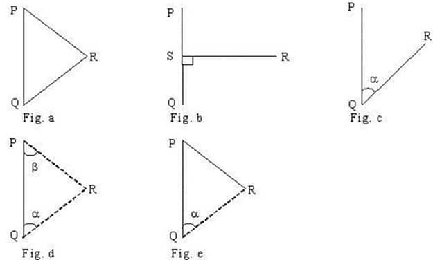
If P and Q are the two reference points on the ground, any other point, such as R, can be located by any of the direct methods shown in the above figures. But, although a single method is sufficient to locate the relative position of ‘R’ with respect to reference points P and Q, it is necessary to adopt at least any two methods to fix the position of point ‘R’.
While the measurements made in the either of the first method or second method will be helpful in locating the point ‘R’, the measurements made in the other method will act as a check.
Working from whole to part

According to this principle, it is always desirable to carryout survey work from whole to part. This means, when an area is to be surveyed, first a system of control points is to be established covering the whole area with very high precision. Then minor details are located by less precise methods.
The idea of working this way is to prevent the accumulation of errors and to control and localize minor errors which, otherwise, would expand to greater magnitudes if the reverse process is followed, thus making the work uncontrolled at the end.
No comments:
Post a Comment