
Method of Surveying in Civil Engineering
Primary types of Surveying are:
Plane surveying
Geodetic surveying
1. Plane surveying
Plane surveying is conducted by state agencies as well as private agencies. As we know earth is spherical in shape but its diameter is big enough to consider plane in small dimensions. It is that type of surveying in which the mean surface of the earth is considered as a plane and the spheroidal shape is neglected. All triangles formed by survey lines are considered as plane triangles. The level line is considered as straight and plumb lines are considered parallel. Plane surveying is done of the area of survey is less than 250 km2.
2. Geodetic surveying
Geodetic survey is conducted by survey department of the country. It is that type of surveying in which the curved shape of the earth is taken in to account. The object of geodetic survey is to determine the precise position on the surface of the earth, of a system of widely distant points which form control stations in which surveys of less precision may be referred. . Line joining two points is considered as curved line and angles are assumed as spherical angles. It is carried out if the area exceeds over 250 km2.
Secondary classification of Surveying
Surveys may be classified based on the nature of the field of survey, object of survey and instruments used.
1) Surveying based on Nature of Survey
a) Topographical Surveys
They are carried out determine the position of natural features of a region such as rivers, streams, hills etc. and artificial features such as roads and canals. The purpose of such surveys is to prepare maps and such maps of are called topo-sheets.
b) Hydrographic Survey
Hydro-graphic survey is carried out to determine M.S.L. (Mean Sea Level), water spread area, depth of water bodies, velocity of flow in streams, cross-section area of flow etc.
c) Astronomical Survey
The Astronomical Survey is carried out to determine the absolute location of any point on the surface of earth. The survey consists of making observations to heavenly bodies such as stars.
d) Engineering Survey
This type of survey is undertaken whenever sufficient data is to be collected for the purpose of planning and designing engineering works such as roads, bridges and reservoirs.
e) Archeological Survey
This type of survey is carried out to gather information about sites that are important from archeological considerations and for unearthing relics of antiquity.
f) Photographic Survey
In this type of survey, information is collected by taking photographs from selected points using a camera.
g) Aerial Survey
In this type of survey data about large tracks of land is collected by taking photographs from an aero-plane.
h) Reconnaissance Survey
In this type of survey, data is collected by marking physical observation and some measurements using simple survey instruments.
2) Surveying based on Type of Instruments
a) Chain Surveying
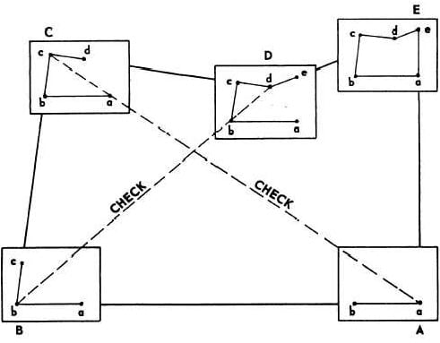
Chain surveying is the basic and oldest type of surveying. The principle involved in chain survey is of triangulation. The area to be surveyed is divided into a number of small triangles. Angles of triangles must not be less than 30 degree and greater than 120 degree. Equilateral triangles are considered to be ideal triangles. No angular measurements are taken, tie line and check lines control accuracy of the work.
This method is suitable on level ground with little undulations and area to be survey is small.

b) Compass Surveying
Compass survey uses the principle of traversing. This method does not requires the need to create triangles. It uses a prismatic compass for measuring magnetic bearing of line and the distance is measured by chain. A series of connecting lines is prepared using compass and measuring distances using chain. Interior details are located using offset from main survey lines.
They suitable for large area surveying crowded with many details. It can be used to survey a river course.

The principle of plane table survey is parallelism. They are plotted directly on paper with their relative position. The rays are drawn from station to object on ground. The table is placed at each of the successive station parallel to the position of the last station.
They are basically suitable for filling interior detailing and is recommended when great accuracy is not required.
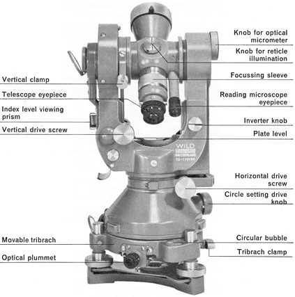
d) Theodolite Surveying
The theodolite is an instrument used mainly for accurate measurement of the horizontal and vertical angles. They are accurate to measure up to 10″ or 20″ angles.
Theodolite can be used to measure:
Horizontal angles
Vertical angles
Deflection angle
Magnetic bearing
Horizontal distance between two points
Vertical height between two points
Difference in elevation
Nowadays theodolite is shadowed and replaced by the use of Total Station which can perform the same task with greater ease and accurate results
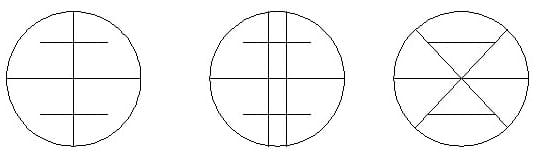
e) Tacheometric Surveying
Tacheometry is a branch of surveying in which horizontal and vertical distances are determined by taking angular observations with an instrument known as a tacheometer. Tacheometer is nothing but a transit theodolite fitted with a stadia diaphragm and an anallatic lens. There is no need for chaining in such survey. The principle of Tacheometer is based on property of isosceles triangle, where ratio of the distance of the base from the apex and the length of the base is always constant.
Different form of stadia diaphragm commonly used:
f) Photographic Surveying
Photographic survey is based on technique of taking photographs from different angle to prepare topographic details with relative high speed.
No comments:
Post a Comment